Um ditado quase que assustador prevê que quando as águas alcançarem os anéis na boca do leão, é porque Londres corre perigo. A cabeça do leão com anel está na parede lateral às margens do rio Tamisa, em Victoria Embankment Gardens. Não apenas um adorno eles são uma marca de nivel, o limite seguro das águas, antes da inundação.
O rio Tamisa nasce a 346 km da costa leste de Londres, sendo um rio de maré, ja chegou a crescer 7 metros. Após anos de medo e de duas grandes inundações, as barragens foram construidas. O projeto vencedor, do escritório Rendel, Palmer and Tritton, é além de um sistema inteligente uma construção escultural na paisagem. Foi inaugurada em 1984 pela Rainha Elisabeth II após de 8 anos de construção.
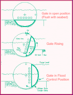
Entre uma estrutura e outra estão as comportas que tem o formato de segmentos cilindricos semi-fechados e que rotacionam no eixo horizontal (veja o corte transversal). O sistema é acionado por computadores conectados a uma estação de meteorológia que manda o alerta de uma possível tempestade e inundação. Inicia-se então o processo de fechamento e durante 9 horas todo o tráfego no rio pára, as comportas subsidiárias fechadas, seguidas pelas barreiras propiamente ditas.
As Barragens do Tamisa foram projetadas para defender Londres de inundações até 2030 sob limites aceitáveis. Além disso, cálculos recentes estimam que mesmo com um possível aumento do nível do mar, devido aos efeitos do aquecimento global, as barragens aguentariam até 2070.
A quite terrifying popular saying tells us that when the water levels reech the rings on the lion's mouth, it means London is in danger. This lion's head is on the Thames bank, at Victoria Embankment Gardens. Not just decorative the figure is a level mark, the safe water level before flooding occurs.
The River Thames rises 346 km from the East cost of London and being a tidal river, it has a rise and fall of 7 meters. After years of fear and two big floods, the Thames Barrier was built. The winning project from the Rendel, Palmer and Triton office, is more than an intelligent system it's a sculpture on the landscape. It was opened in 1984 by Queen Elizabeth II after 8 years of construction.
In between the structures are the flooding gates which are half-open cylindrical segments that rotate horizontally (see the cross section). The system is connected to a forecasting computer station that sends alerts of a possible storm and flooding. The closure process is then started and during the following 9 hours all the river traffic is stopped, subsidiary rivers are closed followed by the barrier itself.
The Thames Barrier was built to protect London from floodings until 2030, withing acceptable limits. Beyond that, recent calculations show that even with possible sea level rises, as a consequence of gobal warming, the barriers would be effective until 2070.

1. Vista das barragens ( observe no terceiro intervalo a comporta se levantando).
2. Mapa da região 3. Corte transversal esquemático do sistema


